CDOT crews take on a challenging weather week
News Release
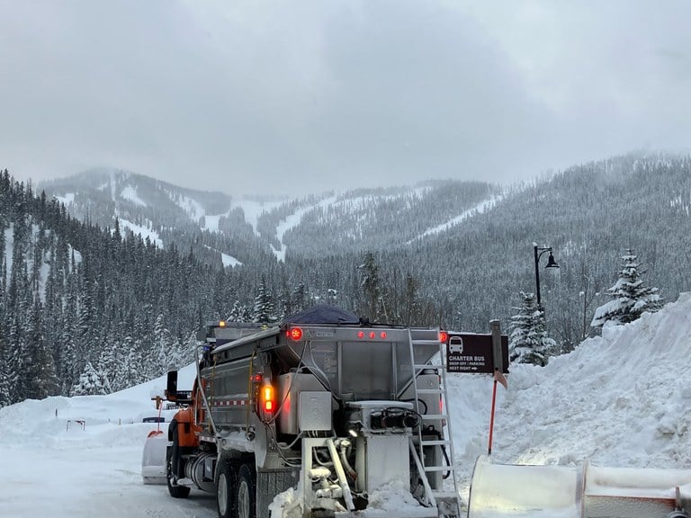
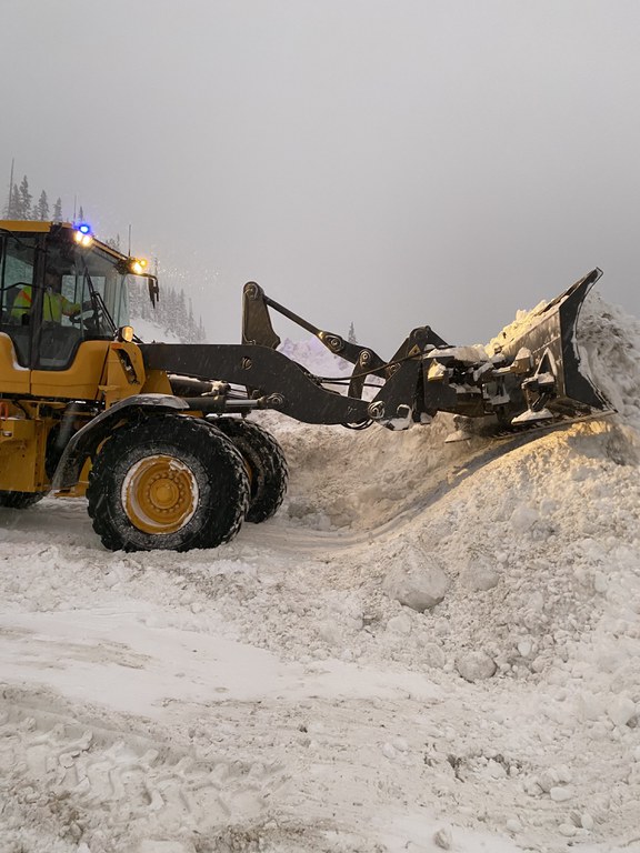
Colorado — Colorado’s high country has experienced conditions closely reminiscent of the March 2019 ‘bomb cyclone’ event that closed much of the State’s mountain highways for an extended period. Storm totals have surged up to 60 inches since Fri., Jan. 12 at many of Colorado’s ski resorts. US 40 Berthoud Pass was one of the most impacted roadways during the course of the storm, having closed on Sun., Jan. 14, and not reopening until the evening of Wed., Jan. 17, due to natural avalanche slides and ongoing adverse conditions. Crews cleared five feet of new snow from the roadway and nearby banks above the road during the severe winter storm.
During the first half of the storm, from Sat. Jan. 13 through Tuesday morning, Jan. 16, Colorado Department of Transportation crews reported 32 bank slides, though more may have occurred. During the closure, Bank slides took place along nearly the entire length of US 40 Berthoud Pass. One example of the storm's severity and snowfall is an unusual slide at Mile Point 235.6, just east of the Mary Jane access to Winter Park Ski Resort. A bank slide at that location was the first observed slide in at least 30 years in that location. The slide was 200 yards long and 10-12 feet high across US 40, which delayed clearing snow from Berthoud Pass and reopening the roadway. In addition to the significant fresh snow totals, strong winds and a weak snowpack layer contributed to conditions leading to many bank slides.
“CDOT crews have been working continuously for a week to clear our roadways and avalanche slide paths to either safely keep open or reopen roads and to ensure the movement of the traveling public and the goods they depend on,” said John Lorme, CDOT’s director of maintenance and operations. “For this team, our mission matters most. While the closures this past week were an inconvenience to motorists, we are proud of the proactive measures we took to close the roads when the conditions were unsafe for the traveling public. We helped minimize the number of crashes on our roadways with our safety closures. We are also proud of our continuing strong partnerships with the Colorado Avalanche Information Center and the Colorado State Patrol. It is unity of effort that gets the job done. We work as one team to strategize on the best ways to keep our roads operational, as weather and circumstances allow, knowing that public safety is our number one concern. We wargame the worst-case scenarios before they happen and implement plans to help prevent those scenarios from coming to fruition, as was the case with our closures on Berthoud Pass and Vail Pass.”


Crews continue work today and through the coming weekend, after moving snow another 4 to 6 feet further to the side of the roadway yesterday. This work is necessary to make room for the next round of snow. Currently, snow is approximately 8 feet high along the roadway. As many as 16 crew members have been part of clearing operations during any given time, using loaders, loaders with blowers, motor graders, and snowplows. CDOT crews from Greeley helped plow starting Thursday, Jan. 18, and more crews and equipment will arrive today to support weekend work. The goal is to allow local crews to rest during the next round of snow. A foot of new snow is in the forecast for the end of this week. As mentioned in a previous news release today, crews also successfully completed winter operations early Thursday morning, which required a 30-minute closure.
“Our crews were relentless in their work to clear the roadways and mitigate avalanche slide paths,” said CDOT Executive Director Shoshana Lew. “I am proud of the work our maintenance and operations team have done over this past week and want to thank all of them for dedicating a tremendous amount of hours that kept them from friends and family in order to serve the people of Colorado. I especially want to thank our maintenance crews from Section 2, who oversee the central mountains and part of the northwest portion of the state and are led by John David; Section 6, who oversee northwest Colorado and are led by Spencer Dickey, and Section 9, who manage I-70 and US 40 through Clear Creek County and are led by Mike Willyard. They have worked tirelessly to open up our roads and make sure the traveling public stays safe. I would also like to thank our crews that came from other regions of the state to help their fellow maintainers and continue to prove they are dedicated and selfless individuals.”
Crews are continuing to monitor the roadway for new bank slides. A small slide came down early Thursday afternoon. Crews held traffic for approximately 30 minutes while clearing the slide; those vehicles were held at locations that are protected from further slides.
“CDOT crews appreciate the overwhelming support from the public on either side of the pass, who have thanked crews for working long, difficult and tiring hours, around the clock for almost a week to safely reopen US 40 Berthoud Pass,” said Lorme. “This past storm was comparable to what we experienced in 2019 with the bomb cyclone event. Though we did not see the same impacts to our urban corridors and eastern plains that we did in 2019, we saw the same kind of intensity and snow totals. Our crews flourish in events like these and our men and women continue to prove that they have what it takes to take on Mother Nature and defend the public against what it brings.”
Motorists should plan on heavy traffic along the I-70 Mountain Corridor and US 40 this weekend as people take advantage of the large amount of snow that accumulated in the high country this week.
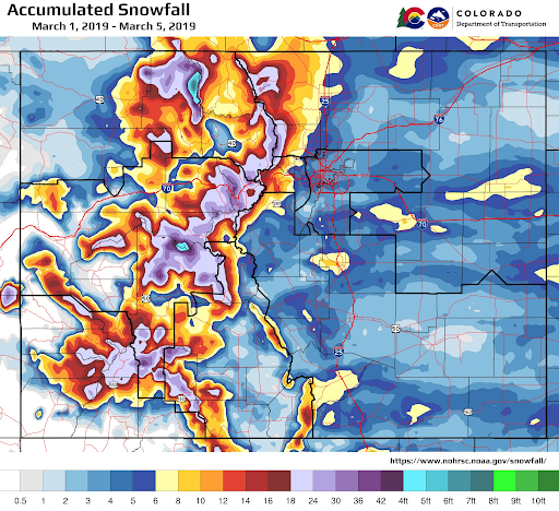
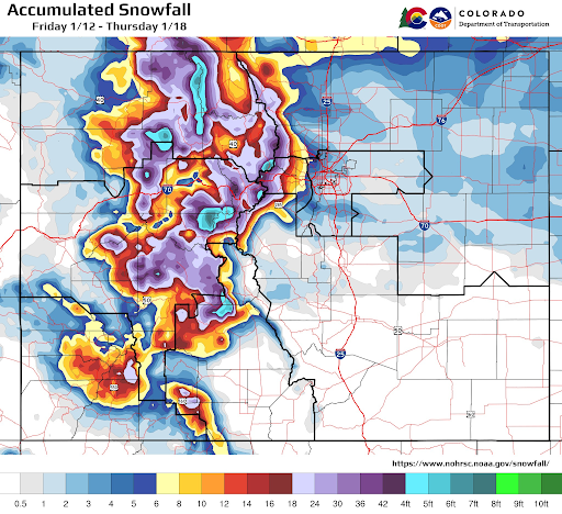
Accumulated snowfall total maps showing the comparison between the 2019 Bomb Cyclone event and this week’s storm:


This latest storm cycle generally did produce more snow in the Northern Mountains than the notorious early-March 2019 event. However, the 2019 event was shorter in duration and much more a single, defined storm. On the contrary, the 2024 episode was composed of several discrete features, including bursts and lulls in precipitation over the course of six days. While both events produced a notable natural avalanche cycle, the 2019 cycle is still considered the worst in Colorado in roughly 100 years.
Know Before You Go
Travelers are urged to “know before you go.” Gather information about weather forecasts and anticipated travel impacts and current road conditions prior to hitting the road. CDOT resources include:
- Road conditions and travel information: COtrip.org
- Download the COtrip Planner app: bit.ly/COtripapp
- Sign up for project or travel alerts: bit.ly/COnewsalerts
- See scheduled construction lane closures: bit.ly/laneclosures
- Connect with @ColoradoDOT on social media: Twitter, Facebook, Instagram and YouTube
Download the COtrip App!
The new free COtrip Planner mobile app was designed to meet the growing trend of information on mobile and tablet devices for the traveling public. The COtrip Planner app provides statewide, real-time traffic information, and works on mobile devices that operate on the iOS and Android platforms. Visit the Google Play Store (Android devices) or the Apple Store (iOS devices) to download!
