
CDOT prioritizes critical flood repairs ahead of holiday travel
Travel Advisory
Media Note: A press briefing was held on Nov. 10 in Durango. An accessible audio and slide deck recording of the full media briefing will be available on CDOT’s YouTube Channel by Wednesday, Nov. 11 at noon.
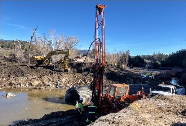
Southwest Colorado — The Colorado Department of Transportation has approximately 15 emergency work zones underway across five different highways following two consecutive flood events that impacted the region in a two-week time span.
“Our teams on the ground have made remarkable progress to make repairs after the two rounds of severe flooding,” said CDOT Executive Director Shoshana Lew. “We won’t stop this work to repair every damaged section of roadway, and some critical milestones that restore connectivity in southwest Colorado are very near. The team is currently on track to get limited traffic on Wolf Creek Pass open by this weekend, with CO 151 open before Thanksgiving. These roads will require speed reductions and extra traffic control, so we will need collaboration from the public to drive safely in these areas.”
CDOT maintenance crews and contractors have been working around-the-clock to reopen critical routes and prioritize extensive repair work on several highways including US Highway 160 Wolf Creek Pass between Pagosa Springs and South Fork.
“Contractors began work to stabilize and restore travel on Wolf Creek Pass only days after the first storm washed out a section of road east of the summit,” said CDOT Regional Transportation Director Julie Constan. “The second round of rain damaged additional sections of road but we are hopeful the pass will open to motorists, with some safety restrictions, by the end of the week.”
As of Nov. 10, three highways remain fully closed - US 160 Wolf Creek Pass, US 160 at Piedra River Bridge and CO 151 south of Chimney Rock Monument.
US 160 Wolf Creek Pass: The second storm system on Nov. 1 caused significant destruction at several new locations along the 26-mile mountain corridor between Pagosa Springs and South Fork. On the east side of the pass, through The Narrows, crews have been reconstructing new segments of road where washouts and undercutting occurred along the river banks. West of the summit, extensive mud and rockslide clearing operations are taking place. Additional work to stabilize highway shoulders, mitigate rockfall and install protective barriers will need to be completed in order to make this roadway safe for the traveling public. US 160 Wolf Creek Pass is anticipated to open within a week, weather dependent. Motorists can expect one-lane alternating traffic through multiple work zones.
CO 151 between Pagosa Springs and Durango: Floodwaters completely washed out two segments of road south of Chimney Rock Monument, which damaged drainage infrastructure along a three-mile stretch of highway (MPs 27 to 30). Work to restore this bypass is critical to gain access between Pagosa Springs and Durango and is anticipated to be completed before Thanksgiving, likely with speed reductions and flaggers at ongoing work zones. Reopening this work zone will eliminate the need for a detour through New Mexico, cutting the 3.5 hour drive down to approximately 1.5 hours between Durango and Pagosa Springs.
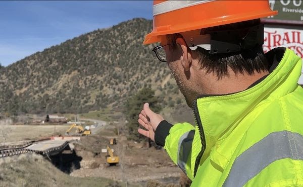
US 160 at Piedra River Bridge: Critical access between the communities of Pagosa Springs and Durango has been severed since Oct. 31 when flood waters collapsed the piers of the Piedra River Bridge (Mile Point 121). The structure requires a complete rebuild. A contractor has begun work to prep the site, remove the remaining sections of the old bridge and begin construction of a temporary bridge on a temporary alignment before winter. After a temporary bridge is in place, work to reconstruct a permanent structure will be completed.
CDOT recommends using COtrip.org or the COtrip Planner App when planning travel routes within the state. Up-to-date highway impacts, detours and closures are most accurate on COtrip. Impacts may change daily and are reflected on COtrip ahead of other mapping sites.
There is considerable damage across the region and significant work is needed to rebuild and repair damaged infrastructure. The Department will continue to provide updates as additional information becomes available.
Know Before You Go
Travelers are urged to “know before you go.” Gather information about weather forecasts and anticipated travel impacts and current road conditions prior to hitting the road. CDOT resources include:
- Road conditions and travel information: COtrip.org
- Download the COtrip Planner app: bit.ly/COtripapp
- Sign up for project or travel alerts: bit.ly/COnewsalerts
- Check scheduled construction lane closures: bit.ly/laneclosures
- Connect with @ColoradoDOT on social media: X, Facebook, Instagram and YouTube
Download the COtrip App!
The new free COtrip Planner mobile app was designed to meet the growing trend of information on mobile and tablet devices for the traveling public. The COtrip Planner app provides statewide, real-time traffic information, and works on mobile devices that operate on the iOS and Android platforms. Visit the Google Play Store (Android devices) or the Apple Store (iOS devices) to download!
