
US 550 Red Mountain Pass opens July 31 between Silverton and Ouray
Travel Advisory
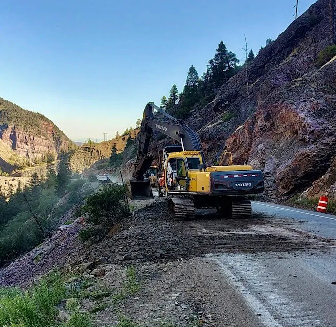
San Juan County — US Highway 550 between Silverton and Ouray opened in both directions on Friday, July 31 at noon after severe flooding prompted an extended two-day closure of Red Mountain Pass. The Colorado Department of Transportation swiftly cleared slide paths from the road surface on Wednesday evening to allow safe passage for motorists who were stranded between debris flows. More extensive rock and mud removal operations along with roadway reinforcement and repairs continued through Friday morning.
Eight slide paths were cleared from the highway with multiple debris fields reported to be over four-feet tall, including the Brooklyns slide area. The Brooklyns are located approximately five miles north of Silverton where snow avalanches frequently hit the highway in the winter.
As monsoon storm patterns continue across the region, motorists are urged to stop, turn around or safely pull over if they see mud, rocks or water flowing onto the highway. Rain falling miles away can trigger rapid mudslides or rockfalls downhill without warning. Recent wildfire areas are especially prone to flooding hazards.
Travelers are reminded of 24/7 alternating traffic and up to 20-minute delays at an ongoing retaining wall and tunnel repair project between Ouray and Ironton. Work is anticipated to be complete in September 2026. Learn more: codot.gov/projects/us550walltunnelrepairs
Motorists are encouraged to check current road conditions and traffic impacts on COtrip.org or download the COtrip Planner app.
Flood safety reminders for motorists
- "Turn around, don't drown." Never attempt to drive through flooded roadways or standing water. Just 12 inches of rushing water can carry away a small car, and the road surface beneath may be completely washed away.
- Beware of burn scars and canyon roads. Rain falling miles away can trigger rapid mudslides or rockfalls downhill without warning. If you see mud, rocks, or water flowing onto the highway, stop or safely pull over before reaching the flow area.
- Reduce speed and turn on headlights. Maintain extra stopping distance between vehicles. Hydroplaning can occur at speeds as low as 35 MPH on wet pavement.
- Avoid cruise control. Using cruise control on wet or slick pavement makes it harder to react to a sudden loss of traction.
- Avoid stopping under overpasses or unstable slopes. If trapped by rising water or a debris slide, stay inside your vehicle if it is safe to do so, or move immediately to higher ground if water begins entering the cabin.
- Watch for lightning at higher elevations. Pull over safely if visibility drops sharply during a storm
Know Before You Go
Travelers are urged to “know before you go.” Gather information about weather forecasts and anticipated travel impacts and current road conditions prior to hitting the road. CDOT resources include:
- Road conditions and travel information: COtrip.org
- Download the COtrip Planner app: bit.ly/COtripapp
- Sign up for project or travel alerts: bit.ly/COnewsalerts
- Check scheduled construction lane closures: bit.ly/laneclosures
- Connect with @ColoradoDOT on social media: X, Facebook, Instagram and YouTube
Remember: Slow For The Cone Zone
The following tips are to help you stay safe while traveling through maintenance and construction work zones.
- Do not speed in work zones. Obey the posted speed limits.
- Stay Alert! Expect the unexpected.
- Watch for workers. Drive with caution.
- Don't change lanes unnecessarily.
- Avoid using mobile devices such as phones while driving in work zones.
- Turn on headlights so that workers and other drivers can see you.
- Be especially alert at night while driving in work zones.
- Expect delays, especially during peak travel times.
- Allow ample space between you and the car in front of you.
- Anticipate lane shifts and merge when directed to do so.
- Be patient!
Download the COtrip App!
The new free COtrip Planner mobile app was designed to meet the growing trend of information on mobile and tablet devices for the traveling public. The COtrip Planner app provides statewide, real-time traffic information, and works on mobile devices that operate on the iOS and Android platforms. Visit the Google Play Store (Android devices) or the Apple Store (iOS devices) to download!
