
US 160 San Juan River Bridge Closed
Travel Advisory
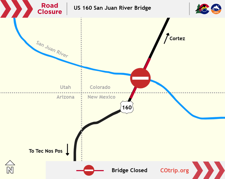
Southwest Colorado - The Colorado Department of Transportation fully closed the US Highway 160 San Juan River Bridge at 7 p.m. on Oct. 24, 2026. The preemptive safety closure is in place to protect motorists from the potential of rising river flows impacting the bridge structure. Motorists traveling on US 160 through the Four Corners area are advised to seek alternate routes. There is no estimated time of reopening as it depends on river flows and weather conditions.
Check the latest road conditions and traffic impacts on COtrip.org or on the COtrip Planner app. Weather has impacted travel throughout the greater southwest. For travel information in all area Four Corners states, visit: NMroads.com, AZ511.gov and udottraffic.utah.gov.
CDOT is urging motorists to avoid travel during the current flood warnings and flood watches issued for southwest and south-central Colorado. If you must travel, avoid driving through flooded areas and never drive through closure gates or barricades.
Multiple full closures remain in place across southwest Colorado. Motorists should be prepared for additional safety closures in other areas of the region where significant flooding is creating roadway hazards. Safety closures may be extended due to weather conditions, water levels and highway damage.
Motorist Safety
When motorists drive up onto a flooded area, there are several precautions to follow.
- Never drive through any flooded area, you do not know how deep or how fast the water is running
- If you are stuck on the roadway during a closure it is best to remain in your vehicle unless absolutely necessary
- Even eight to 10 inches of water can float an average-sized car, which can be easily swept off the road
- Driving too fast on wet roads or in flooded areas can cause a vehicle to hydroplane. Never use your cruise control during rainy conditions with standing water on the roadway
- Any amount of flooding or mud can obstruct the roadway and hinder drivers from knowing exactly where to drive. If you cannot see the roadway, be smart and wait for the water to subside
- Water and mud can contain unknown hazards hidden under the surface – rocks or other debris, like plant material and tree branches.
Be Prepared
Highway closures can last for as little as a few minutes or for as long as several hours. When drivers set out on a trip, especially through high country roads, it is wise to have the car supplied with an emergency kit. The kit should contain at the very minimum: water, snacks, flashlight, and a blanket. Remember to also carry water for your pets if you’re traveling with animals. You may even consider packing some items to keep you or children occupied while waiting in the car. Activity books, colored pencils or a deck of cards can help pass the time.
Know Before You Go
Travelers are urged to “know before you go.” Gather information about weather forecasts and anticipated travel impacts and current road conditions prior to hitting the road. CDOT resources include:
- Road conditions and travel information: COtrip.org
- Download the COtrip Planner app: bit.ly/COtripapp
- Sign up for project or travel alerts: bit.ly/COnewsalerts
- Check scheduled construction lane closures: bit.ly/laneclosures
- Connect with @ColoradoDOT on social media: X, Facebook, Instagram and YouTube
Download the COtrip App!
The new free COtrip Planner mobile app was designed to meet the growing trend of information on mobile and tablet devices for the traveling public. The COtrip Planner app provides statewide, real-time traffic information, and works on mobile devices that operate on the iOS and Android platforms. Visit the Google Play Store (Android devices) or the Apple Store (iOS devices) to download!
