
Southwest Colorado Flood Response & Recovery
Southwest Colorado Flooding Overview
Current Road Closures & Travel Restrictions
The following road closures are in place:
- CO 151 - Chimney Rock to Arboles (Mile Point 27 to 30)
- US 160 - Wolf Creek Pass to South Fork (MP 157 to 184.5)
- US 160 - Bayfield to Pagosa Springs (MP 121 to 127)
- Residential and emergency traffic only, no through travel permitted
Alternate Routes & Detours
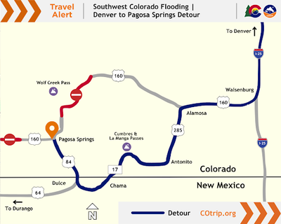
- From Denver to Pagosa Springs (travel time, 6+ hours):
- I-25 south into Walsenburg
- Take US 160 west to Alamosa
- In Alamosa, take US 285 south to Antonito
- In Antonito, take CO 17 south to Chama, N.M.
- Turn right on US 84 north to Pagosa Springs
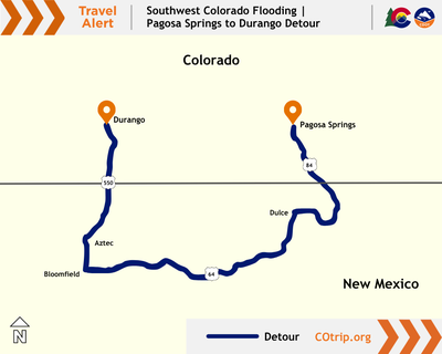
- Essential travel from Pagosa Springs to Durango (travel time, around 2.5 hours)
- US 84 south into New Mexico
- Turn right onto US 64 west to Dulce, N.M.
- At Dulce continue west on US 64 to Bloomfield, N.M.
- At Bloomfield turn right or onto US 550 north to Aztec, N.M.
- Continue north on US 550 into Colorado and Durango
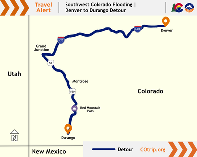
- From Denver to Durango (travel time, just over 8 hours)
- I-70 west to Grand Junction
- US 50 south to Montrose
- US 550 south to Durango (freight drivers should to consider the westerly alternate route via CO 145 through Telluride)
Travel Alerts
The following traffic incidents are in effect across Southwestern Colorado due to flooding:
- US 160 - Between Oakridge Drive and County Road 139 (MP 134.2 to 135)
- There is alternating, single-lane traffic and up to 20 minute delays in both directions
- US 84 (MP 4) in both directions
- Between Navajo River Road and Spring Valley Ranch Road there is alternating single-lane traffic and up to 20 minute delays in both directions between Chromo, Colo. and Chama, N.M.
- US 84 in both directions between Lower Blanco Road and Blanco Basin Road (MP 19)
- There is alternating single-lane traffic and up to 20 minute delays in both directions between Pagosa Springs and Chama, N.M.
Current Recovery & Repair Status
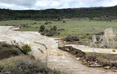
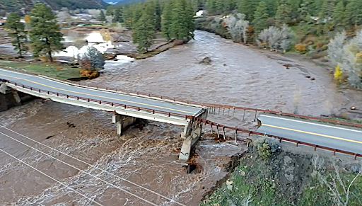
CO 151 road washed away at MP 30 on Oct. 10, 2026 CDOT maintenance crews and contractors are making temporary repairs to reopen roads where possible. Design and engineering staff are developing plans for permanent repairs. US 160 Wolf Creek Tunnel to South Fork (MP 176 to 180) in Mineral County and US 160 Piedra River Bridge (MP 121) in Archuleta County are priorities to reopen and temporarily repair prior to the start of winter.
CDOT requested $65 million in Emergency Relief funds from the Federal Highway Administration and $6.5 million (10% of the original request) in Quick Relief funds to allow CDOT to move forward with immediate repairs. Additionally, The Colorado Transportation Commission also provided $5 million from the Transportation Commission contingency fund.
Repairs and reconstruction are challenging. The emergency closures along many routes limit how quickly crews can deliver and move workers, equipment and materials. The storms and flooding require water removal, flow diversion and debris cleanup at these work sites, which may also slow construction activity.
