US 6 West Access Control Plan
About the Project
Update:
In 2010, the Colorado Department of Transportation, the City of Fruita, the City of Grand Junction and Mesa County adopted the US Highway 6 Access Control Plan (ACP) for US 6 between Loma and Grand Junction. The ACP provided the agencies with the ability to address access on this corridor. Defined by the State Highway Access Code (SHAC), an ACP is a method for local government and CDOT to cooperatively plan for future access to the State Highway System. Local agencies participate in making decisions about access that are consistent with local communities’ vision, existing and future land use, and the local transportation system rather than have access defined solely by criteria from the SHAC.
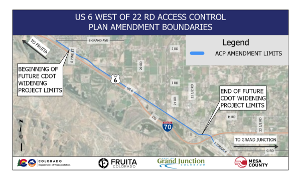
The partner agencies have now identified a need to amend the existing plan to support a future widening on US 6 between 18 Road and 22 Road.
The widening project is organized into two phases:
- Phase One covers the segment east of 20 Road
- Phase Two covers the segment west of 20 Road
While access changes are limited, the project team is evaluating business and residential access concepts to accommodate the anticipated updates to the Access Control Plan. These concepts are being evaluated for potential right-of-way impact, parking, access control, roadway widening, intersection configuration changes, and overall traffic impacts.
Schedule & Important Dates
- Public Open House
- Wednesday, Oct. 21, 2026 from 5 p.m. to 7 p.m.
CDOT Bookcliff Conference Room
2328 G-Road
Grand Junction, CO 81505 - Thursday, Oct. 22, 2026 from 5 pm. to 7 p.m.
Fruita Civic Center
325 E. Aspen Ave.
Fruita, CO 81521
- Wednesday, Oct. 21, 2026 from 5 p.m. to 7 p.m.
Project Area