
CO 119 Safety, Mobility & Bikeway
About the Project
By the year 2040, the Diagonal Highway between Boulder and Longmont is expected to see a 25% increase in vehicular traffic. Increased traffic can result in more congestion, delays, tailpipe emissions and potentially more crashes. CDOT, the Regional Transportation District and Boulder County are taking action to mitigate these outcomes and expand transportation options.
The CO 119 Safety, Mobility and Bikeway project will make improvements to the corridor, resulting in safer, faster and more reliable travel for all modes of transportation. The project spans Colorado Highway 119/Diagonal Highway, between Boulder and Longmont, from approximately Foothills Parkway to Hover Street. The project is designed to integrate with other active multimodal projects on the corridor.
Project Facts
- Program Cost: $165 million
- Contractor: Kraemer North America
- Timeline: Fall 2024 to Spring 2027
- Location: CO 119 between Boulder and Longmont
- Nearest Towns/Cities: Boulder and Longmont
- Mile Point(s): 44.5 to 54.5
- County: Boulder
To sign up for the weekly construction update emails, follow these steps:
- Select the "Sign up for CO 119 Mobility Project Updates" button on the right side of the page
- Scroll to the "Construction Updates & News Releases" section, select "Subscribe to Construction Updates"
- Enter your email address, select "Northeast Colorado" as the region, check "Front Range I-25 Corridor" and "CO 119 Safety & Mobility Improvements"
- Submit!
The Construction Manager/General Contractor (CM/GC delivery method) is being used to build the project. Construction started in September 2024.
Check out the online presentation videos to learn more about the safety, mobility, and bikeway improvements. Email [email protected] if you wish to receive this presentation in Spanish.
Project Area
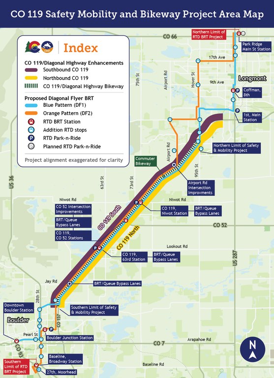
Key features include:
- Bus Rapid Transit (BRT) Stations: Marked with red bus icons along CO 119
- Park-n-Ride Locations: Indicated with blue "P" icons at various stations
- Operational & Safety Improvements: Shown with green intersection icons
- Bus Queue Bypass Lanes: Denoted with a gray bus with a green arrow
Proposed RTD BRT Routes:
- Blue Line (DF1): Minimum of 30-minute weekday service and up to 30-minute weekend service between Longmont and Downtown Boulder Station via 28th Street
- Orange Line (DF2): Up to 30-minute AM and PM peak service, weekdays only, between Longmont and Boulder via Boulder Junction at Depot Square Station
- A list of all stops associated with the proposed BRT service is available by downloading the RTD Diagonal Flyer Stop List from the Denver RTD website.
Additional features:
- Intersection reconfiguration at CO 52/Mineral Road
- Northern and southern project limits marked in Longmont and Boulder, respectively
Major roads and highways are also labeled, including Airport Road, Hover Street, Niwot Road, Lookout Road, Jay Road, CO 52/Mineral Road, CO 119 and CO 157.
Project Improvements
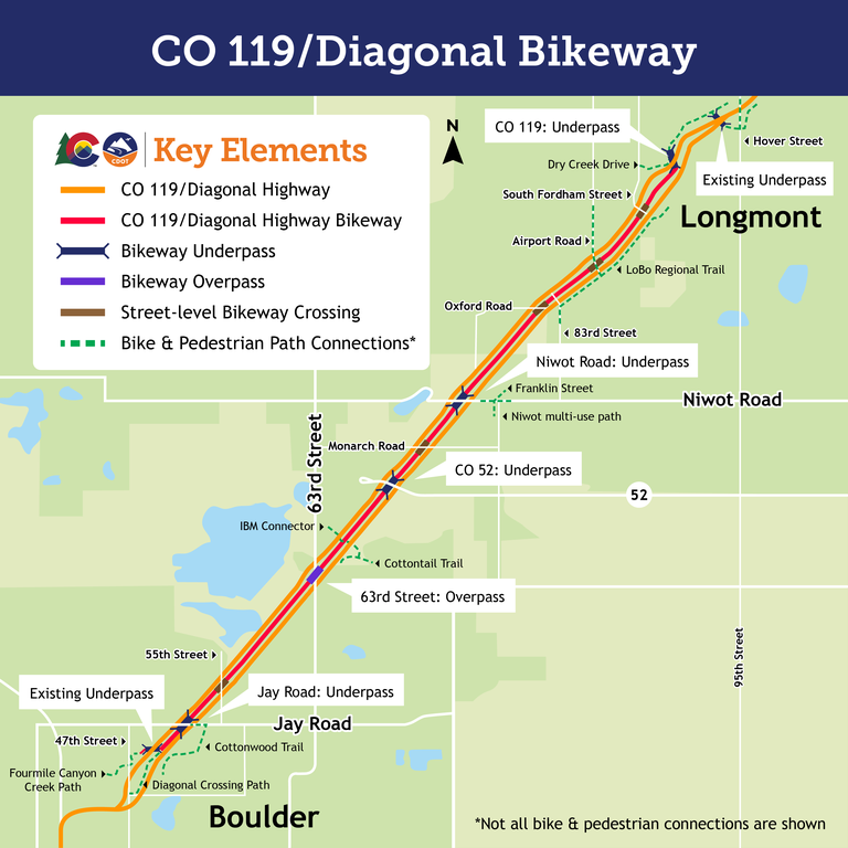
- Addition of a commuter bikeway (Diagonal Bikeway) with several local connection points between northbound and southbound CO 119. Underpasses or overpasses will be added at major intersections for safe and uninterrupted cyclist crossing
- Four underpasses
- CO 119 underpass
- Niwot Road underpass
- CO 52 underpass
- Jay Road underpass
- One overpass
- 63rd Street overpass
- Four underpasses
- New signage, striping and improved signal timing at all pedestrian crossings at signalized intersections
- Signal timing adjustments at key intersections (Jay Road, 63rd Street, CO 52, Niwot Road and Airport Road)
- Physically reconfiguring the CO 52 intersection to improve safety and to accommodate new Bus Rapid Transit (BRT) stations and the Diagonal Bikeway between the northbound and southbound travel lanes
- Changing access at Airport Road and CO 119 to reduce crashes and to improve safety and traffic flow
- Changes to unsignalized intersections (55th Street, Monarch Road, Oxford Road and 83rd Street (pair) and Fordham Street) to increase driver safety and prevent crashes.
Project Goals
- Improve safety in the whole corridor
- Maximize the number of people able to move through the corridor
- Maximize intersection operational efficiency
- Improve transit travel times and increase ridership
- Maximize corridor-wide operational efficiency
- Increase opportunities for bicycle commuting and connectivity to the bicycle and pedestrian network
Project Benefits
- Vehicles can move through the corridor faster, with shorter wait times at traffic lights, resulting in fewer crashes
- Traveling the corridor by bus will take about half the time it currently does
- More frequent bus service supports greater travel flexibility
- Safer and more comfortable environment for pedestrians and cyclists accessing the corridor
- Integration between Bus Rapid Transit, Park-n-Rides, pedestrian crossings and the Diagonal Bikeway enables commuters to switch travel modes safely and reliably
Project Schedule
- Construction began in September of 2024
- The project is scheduled for completion in Spring of 2027
Traffic Impacts
Lane Closures
63rd Street Median Closures
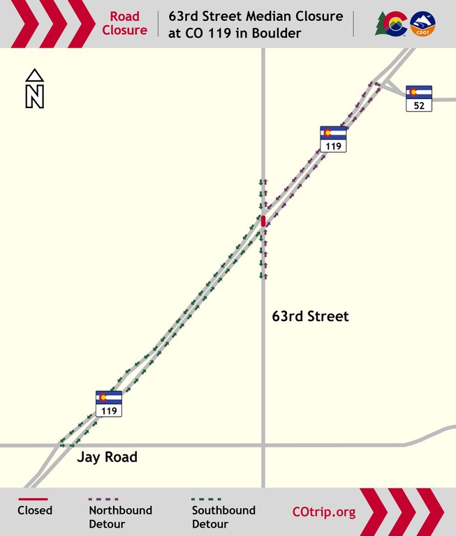
Sunday Oct. 18, at 7 p.m. to Sunday, Oct. 25 the 63rd Street median, between northbound and southbound Colorado Highway 119/Diagonal Highway, will be temporarily closed to all modes of transportation as crews complete traffic signal, roadway and concrete work.
During the closure, 63rd Street and CO 119/Diagonal Highway will be configured as a right-in-right-out intersection. There will be one signed detour route for motorists and cyclists.
Ahead of the full closure on Sunday, Oct. 18 at 7 p.m., the single, right-lane closure on southbound 63rd Street, in the median between northbound and southbound CO 119/Diagonal Highway, remains in place.
Detour:
- Northbound 63rd Street: Turn right onto northbound CO 119, left at Colorado Highway 52, and then left onto southbound CO 119 to return to 63rd Street.
- Southbound 63rd Street: Turn right onto southbound CO 119, turn left onto Jay Road and turn left onto northbound CO 119 to return to 63rd Street.
Sunday, Oct. 18, 7 p.m. to 5 a.m., there will be overnight various right and left lane closures on CO 119/Diagonal Highway, corridor-wide for roadway striping maintenance.
Monday, Oct. 19, to Thursday, Oct. 22, 7 p.m. to 5 a.m., there will be nightly, overnight various right and left lane closures on CO 119/Diagonal Highway, near 63rd Street to place permanent roadway striping.
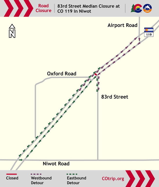
Oxford Road and 83rd Street Median Closures
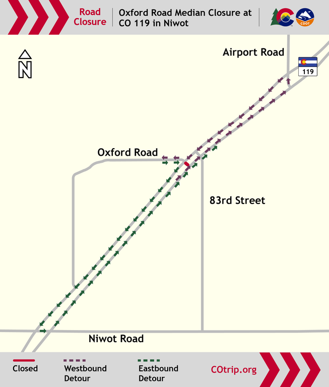
On Thursday, Oct. 22, the Oxford Road and 83rd Street medians, between northbound and southbound Colorado Highway 119/Diagonal Highway, will be closed from 7 a.m. to 5 p.m. These closures will alternate and not occur at the same time.
Detour for Oxford Road Median Closure at CO 119 in Niwot:
- Northbound CO 119/Diagonal Highway travelers intending to turn left on Oxford Road will pass Oxford Road and continue on northbound CO 119 to turn left onto the Airport Road median, turn left onto southbound CO 119 and turn right to access Oxford Road.
- Southbound CO 119/Diagonal Highway travelers intending to turn left on Oxford Road will pass Oxford Road and turn left onto the Niwot Road median, then turn left to access northbound CO 119. This will also be the signed detour route for cyclists.
Detour for 83rd Street Median Closure at CO 119 in Niwot
- Northbound CO 119/Diagonal Highway travelers intending to turn left on 83rd Street will pass 83rd Street, continue on northbound CO 119, turn left onto the Airport Road median and turn left and continue onto southbound CO 119.
- Southbound CO 119/Diagonal Highway travelers intending to turn left onto 83rd Street will pass 83rd Street, continue on southbound CO 119, turn left onto the Niwot Road median and turn left to continue onto northbound CO 119. This will also be the signed detour route for cyclists.
Ongoing Closures
CO 119/Diagonal Highway and Hover Street Intersection Turn Lane Closures:
- All left turns at the CO 119/Diagonal Highway and Hover Street intersection in Longmont are closed for the construction of a new Boulder-bound bridge and other safety improvements. The right turn from southbound Hover Street to southbound CO 119, toward Boulder, is also closed.
- The closures will last until late 2027. All business access will be maintained throughout construction.
- Please use the overview video and maps below for more information about the alternative route options for roadway users at the CO 119/Diagonal Highway and Hover Street intersection. Detailed detour information can also be found below.
CO 119/Diagonal Highway and Hover Street Intersection Detours:
- Right turn closure: Southbound Hover Street to southbound CO 119/Diagonal Highway
- Go west on Clover Basin Drive, south on Airport Road, then south on CO 119.
- Alternatively, continue south on Hover Street/N 95th Street (through CO 119), go west on Colorado Highway 52, then south on CO 119.
- Left turn closure: Northbound Hover Street to southbound CO 119/Diagonal Highway
- Continue north on N 95th Street/Hover Street (through CO 119), go west on Clover Basin Drive, south on Airport Road, then south on CO 119.
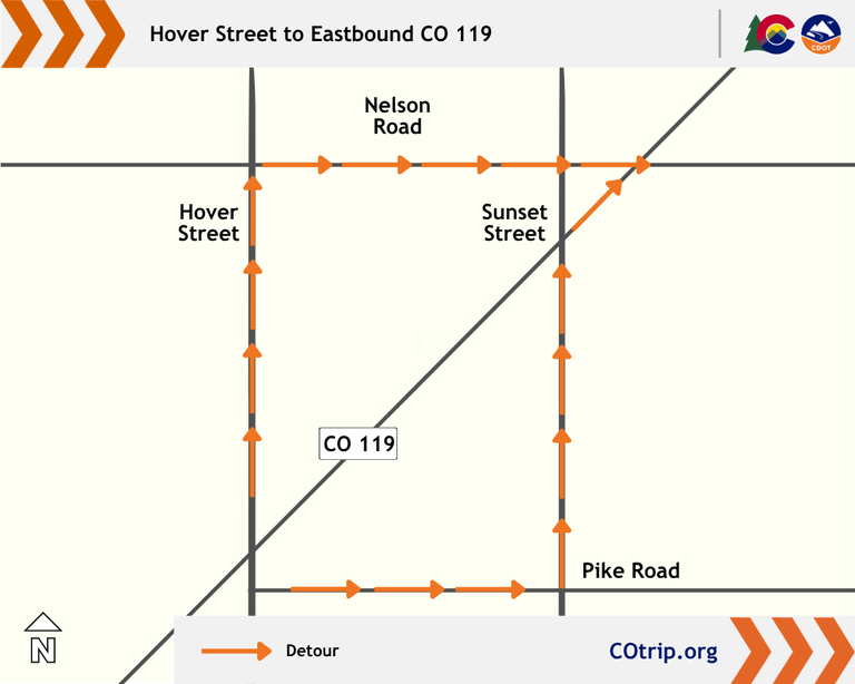
A map showing two of the routes drivers can take from Hover Street to eastbound CO 119 in Longmont.
- Continue north on N 95th Street/Hover Street (through CO 119), go west on Clover Basin Drive, south on Airport Road, then south on CO 119.
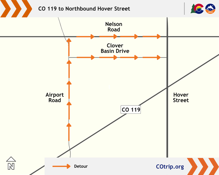
- Left turn closure: Northbound CO 119/Diagonal Highway to northbound Hover Street.
- Go north on Airport Road, east on Clover Basin Drive or Nelson Road, then north on Hover Street.
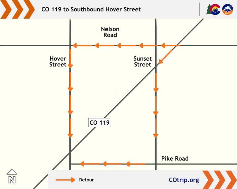
- Left turn closure: Southbound CO 119/Diagonal Highway to southbound Hover Street
- Go west on Nelson Road, then south on Hover Street.
- Alternatively, go south on Sunset Street, west on Pike Road, then south on Hover Street.
63rd Street Closures
- Right Lane: The single, right-lane closure on southbound 63rd Street, in the median between northbound and southbound CO 119/Diagonal Highway, will remain in place through late October.
- On Sunday, Oct. 18, from 7 p.m. to 5 a.m. overnight, the 63rd Street median, between northbound and southbound CO 119/Diagonal Highway, will be temporarily closed to all modes of transportation as crews perform traffic signal work.
- Beginning on Tuesday, Oct. 20, at 6 a.m. until Sunday, Oct. 25, the 63rd Street median, between northbound and southbound CO 119/Diagonal Highway, will be closed again as crews complete roadway and concrete work.
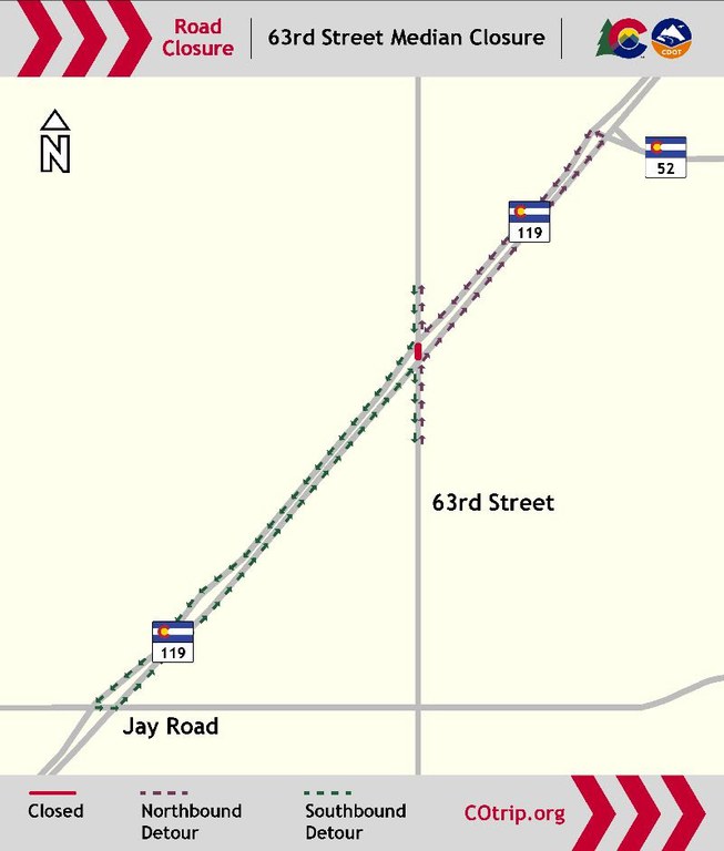
A map showing the 63rd Street median closure with the northbound detour indicated using CO 52. The southbound detour is indicated using Jay Road. - Detour for both closures include:
- Northbound 63rd Street travelers should turn right onto northbound CO 119, turn left at Colorado Highway 52, and turn left onto southbound CO 119 to return to 63rd Street.
- Southbound 63rd Street travelers should turn right onto southbound CO 119, turn left onto Jay Road and turn left onto northbound CO 119 to return to 63rd Street.
Temporary Closure of RTD Bus Stop at CO 119 & 47th Street
- The closure of the RTD bus stop on northbound CO 119/Diagonal Highway at 47th (Stop #17993) remains closed for general improvements, affecting service by the BOLT bus route between Boulder and Longmont. This closure will last through late October.
Fourmile Canyon Creek Trail Closure
- The segment of Fourmile Canyon Creek multi-use path, between 47th Street and Foothills Parkway, is closed as crews construct bikeway connections. Access to this path is completely prohibited while the closure is in place — entering between the barriers into the work zone is extremely unsafe. This closure began on June 25 and is expected to last several months. Detours for this closure include:
- From northbound CO 119: Turn south on the trail at CO 119/Diagonal Highway, continue toward Independence Road, and north onto 47th Street to reconnect to the Fourmile Canyon Creek trail.
- From 47th Street: Continue south on 47th Street, head east on Independence Road, then north on the multi-use path to return to the trail.
- From southbound Foothills Parkway: Continue south toward the Foothills Parkway/CO 119 interchange (near Mountain View Memorial Park) to reconnect to the Fourmile Canyon Creek trail.
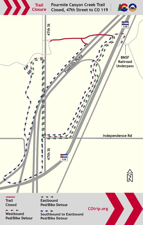
Fourmile Canyon Creek Trail detour map at 47th Street to CO 119. Map outlines the eastbound, westbound and southbound to eastbound pedestrian/bike detour. Details are listed above.
Travel Reminders
Traffic-Pacing Operations
Intermittent traffic-pacing operations will occur on CO 119/Diagonal Highway throughout construction while crews move equipment across the highway. Traffic will move slower and may result in brief traffic holds as part of this work. Please be patient and do not pass the traffic-pacing vehicles — passing them poses a safety risk to all drivers on the road. Thank you for your patience!
Respect the Cone Zone
As you travel through the construction zone, please stay in designated traffic areas. The construction site is strictly off-limits for drivers, cyclists and pedestrians. Entering between barriers or cones at any time is extremely unsafe for travelers and project crews. Law enforcement is on site regularly to monitor traffic, and fines are doubled in the construction zone.
Colorado Speed Enforcement Program
The Colorado Speed Enforcement program is active in the CO 119 Safety, Mobility and Bikeway work zone. The program addresses high speeds by using camera technology to track and enforce speed limits. Learn more by visiting the Colorado Speed Enforcement program page.
Help Ease Traffic: Explore Alternative Transportation During Construction
Hey, drivers! We know construction along CO 119/Diagonal Highway can be a hassle, and we're working hard to improve this corridor for everyone. In the meantime, we encourage the use of alternate modes of transportation to help reduce traffic and make your commute easier. Whether it’s carpooling, biking or using public transit, every little bit helps ease congestion and keep things moving smoothly for everyone. Thanks for your patience and support – we’ll get there faster together!
