Federal Boulevard Bus Rapid Transit | Design Phase
About the Project
The Colorado Department of Transportation has started environmental review and design work on building a Bus Rapid Transit (BRT) route that could span up to 18 miles of Federal Boulevard.
Federal Boulevard is one of the busiest transit corridors in metro Denver. Currently, buses on the corridor experience significant delays, resulting in long travel times. BRT will reduce travel times and improve reliability.
Schedule & Important Dates
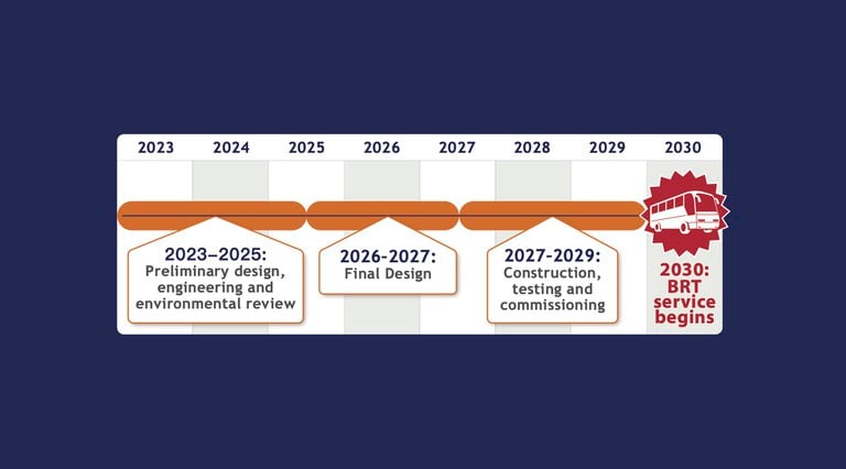
Project Timeline
- 2023 to 2025: Preliminary design, engineering, and environmental review
- 2026 to 2027: Final design
- 2027 to 2029: Construction testing, and commissioning
- 2030: BRT service underway
Informational video about what Bus Rapid Transit looks like on Federal Boulevard
Environmental & Design Work
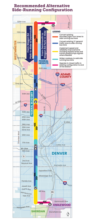
CDOT is conducting the environmental and design work based on the Federal Boulevard BRT alignment recommended through the Denver Moves Federal Transit Alternatives Analysis Summary Report and Westminster’s Federal Boulevard Multimodal Transportation Study. Those two plans recommended the side-running BRT option, in which the BRT line would have a dedicated curbside lane, except for between 20th and 50th avenues where the BRT would share lanes with other vehicles.
Potential Project Timeline

2026 to 2027: Final design
2027 to 2029: Construction testing, and commissioning
2030: BRT service underway
Project Area

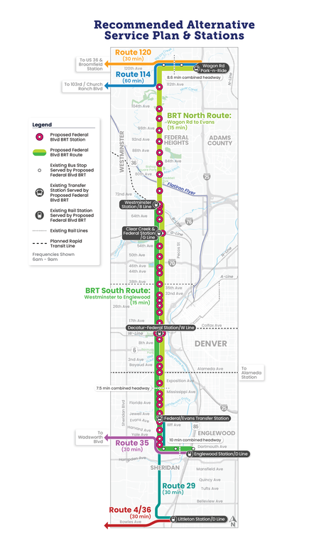
BRT Potential Station Locations

Proposed Improvements Map

- Provide reliable, high-frequency bus service along 18 miles of Federal Blvd from northern Westminster southern Denver, one of the highest ridership transit corridors in the Denver region
- Increase safe, accessible and affordable transportation choices for all travelers
- Improve safety by helping to prevent crashes involving pedestrians, bicyclists and vehicles on heavily traveled urban roads
- Increase the number of people who can travel on a road while using fewer vehicles, ultimately easing congestion and reducing greenhouse gas emissions
• Improve safety along the corridor and at transit station areas
• Increase transit reliability and ridership
• Decrease transit travel times
• Promote cultural vibrancy and quality of life along the corridor
• Increase accessibility via transit
• Improve connectivity and mobility
Letter of Interest Resources
- Letter of Interest Request (LOI) – Coming soon
- Letters of Interest Received for Federal Boulevard BRT Project
Project Delivery Selection Matrix Resources (PDSM)
- Federal Boulevard BRT PDSM Summary
- Federal Boulevard BRT Construction Manager/General Contractor (CMGC) Chief Engineer Memo
- Federal Boulevard BRT CMGC Transportation Commission Resolution
Industry Outreach Meeting Presentation & Resources
Watch the presentation on YouTube
The project team hosted an update on the proposed delivery approach for the Federal Boulevard BRT from Dartmouth Avenue to 120th Avenue on Dec. 17, 2025. The meeting included a presentation followed by an opportunity to ask questions and provide feedback. The presentation provides an overview of the project and the alternative delivery selection process and recommendation.
- Federal Boulevard BRT Alternative Delivery Industry Outreach Summary
- 2025 Industry Review Announcement
- 2025 Project Delivery Update to Industry
