Get Involved!

About the Transportation Planning Regions
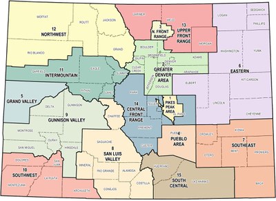
Colorado is divided into 15 regions: 10 rural Transportation Planning Regions (TPRs) and five Metropolitan Planning Organizations (MPOs). Each region creates a Regional Transportation Plan (RTP) to address its specific needs and priorities, which are then combined into the Statewide Transportation Plan.
We Want Your Input
Looking for ways to join the conversation and stay updated? Please see the website links below to connect you with information about what's going on in your area of the state and ways to get involved.
Transportation Planning Regions Overview
| TPR and MPO Website | Counties |
|---|---|
| Central Front Range | Custer, Fremont, Park, part of El Paso and a part of Teller. |
| Eastern | Cheyenne, Elbert, Kit Carson, Lincoln, Logan, Phillips, Sedgwick, Washington and Yuma. |
| Gunnison Valley | Delta, Gunnison, Hinsdale, Montrose Ouray and San Miguel |
| Intermountain | Eagle, Garfield, Lake, Pitkin and Summit |
| Northwest | Grand, Jackson, Moffat, Rio Blanco and Routt |
| San Luis Valley | Alamosa, Chaffee, Conejos, Costilla, Mineral, Rio Grande and Saguache |
| South Central | Huerfano and Las Animas |
| Southeast | Baca, Bent, Crowley, Kiowa, Otero and Prowers |
| Southwest | Archuleta, Dolores, La Plata, Montezuma, and San Juan |
| Upper Front Range | Morgan, part of Larimer and a part of Weld |
| Denver Regional Council of Governments (DRCOG) | Adams, Arapahoe, Broomfield, Boulder, Clear Creek, Denver, Douglas, Gilpin and Jefferson |
| Grand Valley MPO (GVMPO) | Mesa |
| North Front Range MPO (NFRMPO) | Part of Larimer and part of Weld |
| Pikes Peak Area Council of Governments (PPACG) | El Paso and Teller |
| Pueblo Area Council of Governments (PACOG) | Pueblo |
Know Before Your Go
Travelers are urged to “know before you go.” Gather information about weather forecasts and anticipated travel impacts and current road conditions prior to hitting the road.
CDOT Resources Include:
- Road conditions and travel information: COtrip.org
- Download the COtrip Planner app
- Sign up for project or travel alerts
- See scheduled construction lane closures
Connect with @ColoradoDOT on social media:
